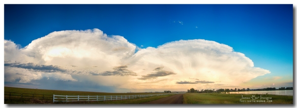
You’re welcome Nebraska! These super thunderstorm cells come flying over the Colorado Rocky Mountains and head out east to the plains. A normal spring summer day on the Rocky Mountains foothills is waking up to clear blue skies over the mountains. By 1:00 pm the clouds start rolling in and building over the foothills sometimes by 3:00 to 4:00 it rains and clears by sunset and the best is when it kicks up at sunset and last till about 11:00pm. Those are the storms best to photograph.
This is a seven image very large panorama of a supercell heading over Denver and out NE to the plains of Nebraska.
Colorado fine art nature landscape photography poster prints, decorative canvas prints, acrylic prints, metal prints, corporate artwork, greeting cards and stock images by James Bo Insogna (C) – All Rights Reserved.
Please feel Free to share our links, with Family or Friends who may also enjoy them.
Striking Fine Art Photography International Gallery
If you like my Art Gallery, please spread the word and press the Pinterest, FB, Google+, Twitter or SU Buttons!
Thank you!
Bo Insogna
Facebook: http://www.facebook.com/StrikingPhotographyByBo
Twitter: http://www.twitter.com/Lightning_Man
Google Plus: https://plus.google.com/u/0/+BoInsogna
Recent Striking Fine Art Photography Prints and Images:
Lake Thunder Cell Lightning Burst
Another Colorado Country Landscape
Filed under: Uncategorized Tagged: clouds, Colorado, cumulonimbus, cumulus, denver, Extreme weather, James bo Insogna, landscape, Nature, pano, panorama, panorama view, panoramas, Photography, severe, sky, storm chasers, storms, Thunderstorms, weather
![]()


Leave a Reply